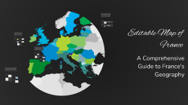
Editable Map of France
Transcript: Practical Applications Educational Uses Tourism Planning Editable maps are crucial for geography education, enabling students to visualize and comprehend France's geographical complexities. Interactive features foster engagement and improve retention of geographical knowledge. Tourism agencies leverage editable maps to highlight attractions, routes, and accommodations. Customization allows travelers to personalize their itineraries, improving their overall travel experience in France. Urban Development Cultural Studies City planners utilize editable maps to analyze spatial data, assess infrastructure needs, and visualize urban growth. Interactive features enhance communication among stakeholders about development strategies. Research in cultural studies benefits from editable maps that illustrate regional demographics, historical events, and cultural landmarks. These maps facilitate a deeper understanding of France's cultural diversity. Geographic Regions of France Southern France Northern France Editable Map of France Renowned for its Mediterranean climate, Southern France boasts popular destinations like Nice and Marseille. It is characterized by picturesque coastlines, vineyards, and a rich culinary tradition influenced by its diverse geography. This region is known for its historical significance, including the Battlefields of Normandy. It features a diverse landscape comprising coastal areas and rolling hills, alongside vibrant cities such as Lille and Rouen. Western France Eastern France Western France is known for its rugged coastline and historical landmarks such as Mont Saint-Michel. It offers diverse landscapes ranging from sandy beaches to agricultural land, contributing to its cultural heritage. Home to the picturesque Alsace region, Eastern France features a blend of French and German cultures. The region is marked by the Vosges mountains and significant historical towns such as Strasbourg and Dijon. Central France Central France, often referred to as the 'Massif Central', is characterized by volcanic plateaus and rural charm. The region is dotted with quaint villages and is less populated, showcasing authentic French culture. Key Landmarks and Features of France Major Cities France is home to several major cities, including Paris, known for its iconic Eiffel Tower, and Marseille, famous for its vibrant port and multicultural atmosphere. Other important cities include Lyon, Toulouse, and Nice, each offering unique attractions that reflect the country's cultural diversity. Historical Sites Natural Landmarks France boasts numerous historical sites, including the Palace of Versailles, a symbol of royal grandeur, and Mont Saint-Michel, an architectural marvel perched on a rocky island. The Roman amphitheater in Nîmes also showcases France's rich history dating back to the Roman Empire. The landscape of France features breathtaking natural landmarks such as the French Alps, known for skiing and hiking, and the stunning cliffs of Etretat along the Normandy coast. Additionally, the lavender fields of Provence and the Calanques National Park highlight France's natural beauty. Cultural Regions France is divided into culturally rich regions such as Normandy, known for its impressionist art, and Provence, famous for its wine and cuisine. The regions of Brittany and Alsace offer unique traditions and festivals that contribute to France's diverse cultural tapestry. A Comprehensive Guide to France's Geography Introduction to the Map Purpose of the Map The Editable Map of France serves as a versatile tool designed for educators, students, and travelers alike. It allows users to customize geographic information, making it easier to understand regional distinctions and navigate the complex geography of France. Overview of Editable Features This map includes several editable features, such as customizable labels, color-coded regions, and the ability to add or remove landmarks. Such flexibility allows users to tailor the map to their specific needs and preferences, enhancing its usability. Importance of Geographic Understanding User Guide for Editing Geographic literacy is essential for making informed decisions in various fields such as education, urban development, and tourism. Understanding regional dynamics fosters awareness of cultural, historical, and environmental factors that shape France. Users can edit the map by selecting regions to modify, adjusting descriptions, and altering visual elements. A step-by-step guide simplifies the process, ensuring that even those with limited technical skills can navigate and personalize the map confidently.